


Simulations Shed Light on Pine Island Glacier’s Stability
February 28, 2014
Linda Vu, +1 510 495 2402, lvu@lbl.gov
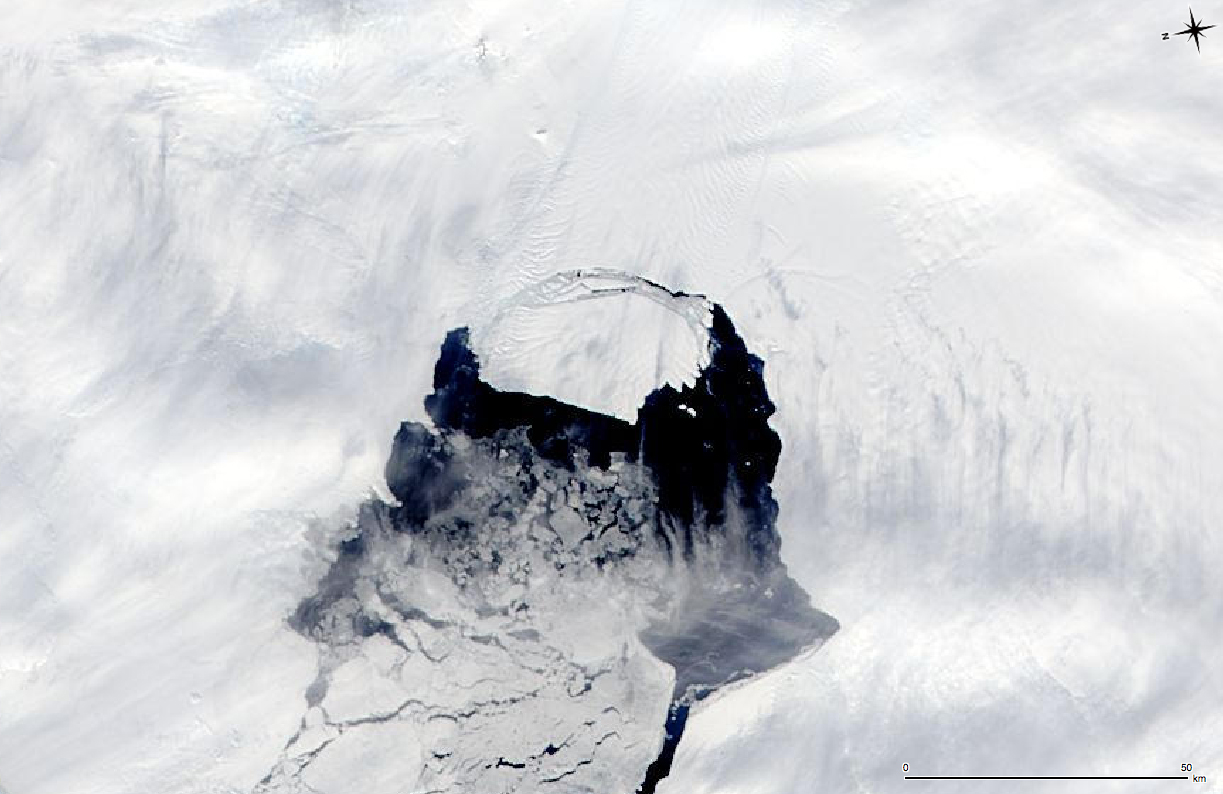
This MODIS image taken by NASA’s Aqua satellite on Nov. 10, 2013, shows an iceberg that was part of the Pine Island Glacier and is now separating from the Antarctica continent. The iceberg is estimated to be 21 miles by 12 miles (35 km by 20 km) in size, roughly the size of Singapore. (Credit: NASA)
The rapid retreat of Antarctica’s Pine Island Glacier (PIG)—the single largest contributor to sea level rise in Antarctica—has perhaps reached a point of no return. Unless the region experiences much colder conditions the retreat will continue, say three international modeling teams writing in Nature Climate Change. They came to this conclusion after running a number of simulations to model the glacier’s behavior.
The simulations also show that PIG mass loss could contribute substantially to global sea level rise over time—on the order of 3.5–10 millimeters in the next 20 years. Today, the glacier accounts for 20 percent of the total ice discharge from West Antarctica. Recent satellite observations suggest that the region is currently contributing about 0.33 millimeters per year to global sea level rise.
"You can talk about external forcing factors, such as climate and ocean effects, and then there are internal factors which are the flow dynamics. What we find is that the internal dynamics of flow are such that the retreat is now self-sustaining,” co-author Hilmar Gudmundsson from the British Antarctic Survey (BAS) tells BBC News.
To do this work, the researchers relied on three different ice-flow models including BISICLES, which was developed by a collaboration that included Lawrence Berkeley National Laboratory (Berkeley Lab) computational scientists.
Runaway Glacier Retreat
Every year PIG—an ice stream on the West Antarctic Ice Sheet—carries approximately 100 cubic kilometers of ice (enough to fill the San Francisco Bay to the level of the Golden Gate Bridge roadway) to the Amundsen Sea. Much of this ice flows through floating ice shelves situated along the coast. Usually, the ice shelves act as buttresses, holding back the ice flow and contributing to the ice sheet’s stability. Because most of the West Antarctic Ice Sheet (including PIG) rests on bedrock below sea level, scientists refer to it as a marine ice sheet.
Since the 1980s, satellite and airborne observations show that West Antarctica’s PIG has been thinning at an accelerated rate. Scientists attribute this to sub-ice-shelf melting, which has been induced by the intrusion of warmer water allowed by a changing circumpolar current—an ocean current that flows clockwise from west to east around Antarctica. Historically, this current has kept warm water away, allowing the continent to keep its massive ice shelves—but this is all changing as the Southern Ocean begins to show the effects of changes in climate.
Over the same period, scientists have also observed that PIG’s grounding line—where the grounded ice sheet separates from the bedrock and begins to float—has retreated tens of kilometers from the submarine ridge it occupied until the 1990s. Today, PIG’s grounding line sits in a deep trough (more than 1000 meters below sea level) that slopes back toward the continent.
Researchers have long suspected that this scenario could lead to a runaway phenomenon called marine ice sheet instability. As the grounding line retreats into the deepening trough, internal ice dynamics cause the ice flowing into the ocean to speed up. The rate of mass loss increases, leading to faster retreat into still deeper bedrock unless the ocean conditions change to allow a thick ice shelf to form. If the ice shelf thickens, the instability acts in reverse and the glacier returns to its relatively stable 1990s position.
“Overall, the short-term behavior of PIG is not well understood and projections vary widely from very modest retreat to almost full collapse within a century,” say the authors. “Assessing the stability of PIG requires numerical models.”
This BISICLES simulation shows the collapse of Antarctica's Pine Island Glacier (in the top left of this simulation) over 200 years. At around 2230, Thwaites Glacier (center-right) begins to collapse as well. Colors indicate ice flow speed, varying from no flow (blue) at the edges up to 4 km per year (red) where Pine Island and Thwaites Glaciers meet the ocean. High resolution is concentrated around and moves with the grounding line (in cyan) as it travels across much of the region.
Mathematical Models Project Glacier Stability
Mathematical models are crucial for understanding how and why glaciers move and change over time. Because satellites like NASA’s MODIS have collected extensive measurements of the changing West Antarctic Ice Sheet (including PIG) over decades, scientists can apply well-understood mathematical equations describing the physics of glaciers to investigate the causes and likely outcome of these changes.
“We started our models where Pine Island Glacier was about 10 years ago; then we adjusted ocean conditions in the region so that the grounding line retreat in our models reflects satellite measurements since then,” says Stephen Cornford of the University of Bristol, a co-author of the paper. “Then we computed grounding line retreat 50 years into the future under different scenarios.”
The team relied on three different models to do this work: Elmer/Ice, BISICLES and Úa. According to Cornford, Elmer/Ice—an open-source finite element software package for modeling the flow of ice sheets and glaciers —provides the most accurate and physically complete model. He notes that this model allows researchers to capture small-scale, non-hydrostatic features like ice bridges, but is also extremely computationally expensive to run. Úa uses a simpler model designed to capture the essential physics of ice flow, which makes it computationally less expensive, while the BISICLES model is somewhat between the other two in physical fidelity and computational cost.
All three models allow researchers to consider regions of interest—like the retreating edge of an ice-sheet—at sub-kilometer spatial resolution while employing computationally cheaper coarser resolution in areas that don’t need such fine detail. This allows an accurate, high-resolution view of phenomena like ice streams and grounding-line migration, at a relatively low computational cost.
According to Cornford, BISICLES is unique in that it can readily modify its computational meshes as the ice sheet evolves, permitting calculations further into the future. Berkeley Lab mathematicians have been leading developers of this technique, known as adaptive mesh refinement.
“BISICLES is much faster to run than Elmer/Ice, largely because it employs a slightly less accurate but computationally far simpler description of the ice physics, but partly because of the high-performance methods it inherits from Berkeley Lab’s Chombo toolkit,” says Cornford, who co-developed the code with Dan Martin from Berkeley Lab. “That meant that we were able to run a number of additional experiments. These additional runs gave us supplementary evidence to support our argument.”
"In spite of the simplified mathematical formulation, the BISICLES calculations compare very favorably with results from the more expensive Elmer/Ice code for the physical examples we are interested in," said Martin, a Berkeley Lab computational scientist. “It’s exciting to see BISICLES being used in this way and contributing to these kinds of results, this is a validation that the code is a useful tool for understanding ice sheet behavior.”
In addition to Cornford and Gudmundsson, other co-authors on the paper include L. Favier, G. Durand, O. Gagliardini, F. Gillet-Chaulet, T. Zwinger, A.J. Payne, and A.M. Le Brocq.
BISICLES was developed with funding from Advanced Scientific Computing Research (ASCR) in the Department of Energy’s Office of Science under the Scientific Discovery through Advanced Computing (SciDAC) Program and the UK Natural Environment Research Council. Computational scientists at Berkeley Lab (Dan Martin, Esmond Ng, and Sam Williams) formed a collaboration with climate scientists at the Los Alamos National Laboratory (William Lipscomb and Stephen Price), which led to the Predicting Ice Sheet and Climate Evolution at Extreme Scales (PISCEES) project, a SciDAC applications partnership.
The BISICLES code was jointly developed with climate scientists at the University of Bristol (Stephen Cornford and Tony Payne) and is publicly available for download with Berkeley Lab’s CHOMBO library, or at http://bisicles.lbl.gov. The development of the code benefited from collaboration with the SciDAC Frameworks, Algorithms and Scalable Technologies for Mathematics (FASTMath) Institute (Mark Adams).
About Berkeley Lab
Founded in 1931 on the belief that the biggest scientific challenges are best addressed by teams, Lawrence Berkeley National Laboratory and its scientists have been recognized with 16 Nobel Prizes. Today, Berkeley Lab researchers develop sustainable energy and environmental solutions, create useful new materials, advance the frontiers of computing, and probe the mysteries of life, matter, and the universe. Scientists from around the world rely on the Lab’s facilities for their own discovery science. Berkeley Lab is a multiprogram national laboratory, managed by the University of California for the U.S. Department of Energy’s Office of Science.
DOE’s Office of Science is the single largest supporter of basic research in the physical sciences in the United States, and is working to address some of the most pressing challenges of our time. For more information, please visit energy.gov/science.